TL;DR —
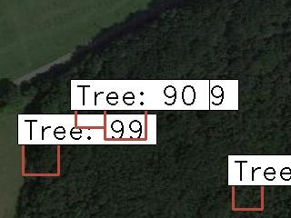
Using Google earth engine, I created a dataset that can spot trees using satellite data. I got the idea from a blog post that used satellite imagery to spot landslides. I used Google Earth engine to create a dataset to create the dataset. The process was described in the blog post below:How our final (semi) automated pipeline ended up working was as follows: Enter coordinates intocropping_coordinates.py to calculate the coordinates of a 10 km square. Copy the output and replace the variables at the top of the JavaScript code in the Google Earth Engine console.
[story continues]
Written by
@tobi-olabode
Technical Writer on HackerNoon.
Topics and
tags
tags
machine-learning|deep-learning|satellite-imagery|cnn|neural-networks|machine-learning-uses|image-processing|image-recognition
This story on HackerNoon has a decentralized backup on Sia.
Transaction ID: ZDIPQt1IiUZeNbiVx5zaqsCswwttMqKnuUI20H0y7Ck