In an era defined by climate urgency and rapid environmental change, our ability to understand, monitor, and react to the pulse of our planet has never been more critical. From tracking deforestation in the Amazon to managing water resources in drought-stricken regions, detailed and up-to-the-minute geospatial information is the bedrock of informed decision-making. Yet, for decades, humanity has faced a monumental challenge: how do we truly see Earth in its entirety, overcoming the inherent complexities of vast data streams, inconsistent information, and the sheer scale of global change?
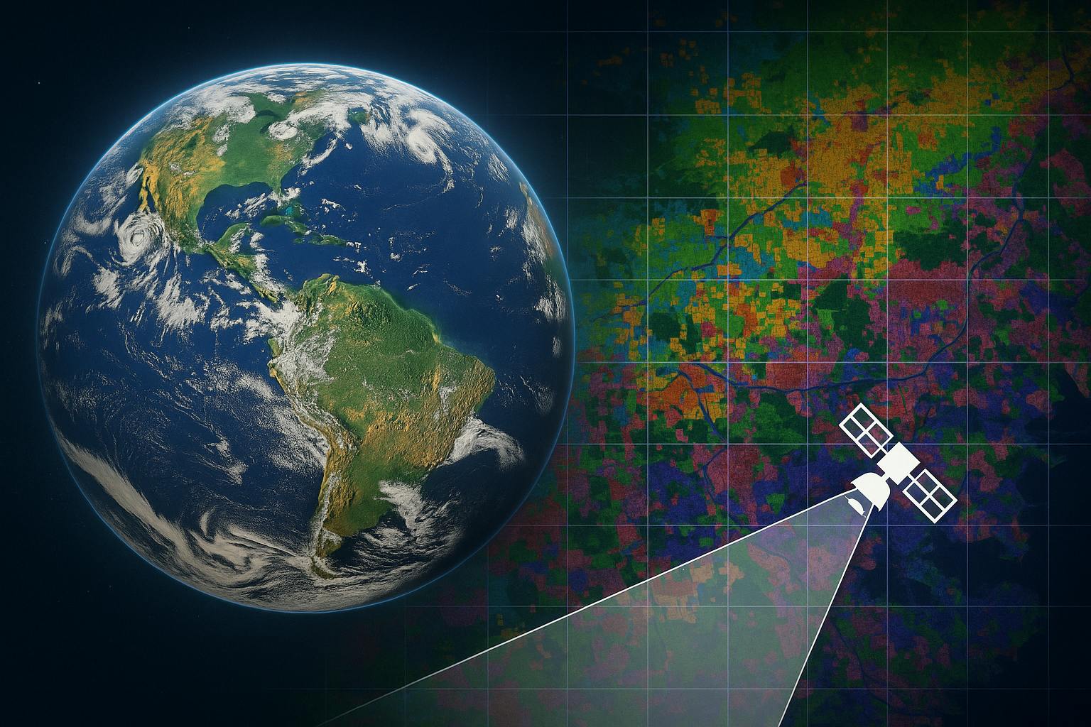
Today, we stand at the precipice of a new era in planetary monitoring, thanks to groundbreaking advancements in artificial intelligence. Imagine a "virtual satellite" that transcends the limitations of its physical counterparts, capable of integrating petabytes of diverse Earth observation data into a single, coherent, and infinitely insightful picture. This isn't science fiction; it's the reality brought forth by AlphaEarth Foundations, a revolutionary AI model from Google DeepMind that is fundamentally transforming how we map and monitor our world in unprecedented detail.
The Unseen Challenges: Why Mapping Earth Was So Hard
For years, scientists and environmental experts have grappled with a paradox: satellites constantly beam down an "unprecedented volume" of information-rich images and measurements, providing a near-real-time view of our planet. This data is incredibly impactful, but its very abundance creates a new set of challenges:
- Data Overload and Disparity: We're drowning in petabytes of information from dozens of different sources – optical images, radar, 3D laser mapping, climate simulations, and more. Each source speaks a slightly different "language," with its own modality, resolution, and refresh rate. Connecting these disparate datasets and making effective use of them all has been a Herculean task.
- The "Sparse Label" Problem: High-quality maps depend on high-quality labeled data, often collected painstakingly on the ground. However, when working at planetary scales, these ground-based measurements are "scarce". It's like trying to draw a detailed world map with only a handful of scattered coordinates.
- Inconsistency and Limitations of Traditional Methods: Existing mapping approaches, whether based on traditional heuristics or earlier machine learning models, often struggle with consistency. They can be noisy, sensor-dependent, and highly localized to specific regions or applications. Many previous AI attempts lacked key properties like true multi-source integration, robust time inclusion, or the spatial precision needed for operational use. They were often good at specific tasks but couldn't offer a truly universal view.
These challenges meant that creating detailed, consistent, and timely maps of our world was often "impossible until now". Scientists had to rely on fragmented data and often wait for a single satellite pass to get their information. The dream of a holistic, dynamic digital representation of Earth remained just that – a dream.
AlphaEarth Foundations: The Virtual Satellite Takes Flight
AlphaEarth Foundations changes everything. At its core, it's an artificial intelligence model that functions like an all-seeing "virtual satellite". It tackles the twin challenges of data overload and inconsistent information head-on.
Here’s what makes it so revolutionary:
- A Universal Translator for Earth's Data: Instead of treating each satellite image, radar sweep, or climate simulation as a separate piece of information, AlphaEarth Foundations combines them all. It "weaves all this information together" from sources like Sentinel-2, Landsat, Sentinel-1, PALSAR-2, GEDI LiDAR, ERA5-Land climate data, GRACE gravity fields, Copernicus DEM elevation, and even geotagged text from Wikipedia and GBIF (Global Biodiversity Information Facility). Think of it as a master translator, capable of understanding and synthesizing all the varied "languages" Earth observation data speaks.
- The Power of "Embeddings": Earth's Digital Fingerprint: The system's "key innovation" lies in its ability to create a highly compact summary for every 10x10 meter square on Earth's terrestrial land and coastal waters. These summaries are called "embeddings," and you can think of them as universal digital fingerprints. Each embedding, just 64 bytes in size, encapsulates a wealth of information about that specific location and time. Crucially, these compact summaries require 16 times less storage space than those produced by other AI systems, dramatically reducing the cost and complexity of planetary-scale analysis. This breakthrough enables scientists to create detailed, consistent maps "on-demand".
- Continuous Time and Space: Seeing Beyond Snapshots: Unlike traditional methods that provide fragmented snapshots, AlphaEarth Foundations models temporal dynamics and relationships across sources, supporting "continuous time". This means it can differentiate between similar surface conditions with different temporal ordering – for example, distinguishing fields with the same crops planted at different times. It can even generate spatially continuous predictions for an arbitrary timestamp, effectively inferring conditions even when direct data for that precise moment or location is sparse or absent (a process called interpolation and extrapolation). This is how the model can "see through persistent cloud cover" to detail agricultural plots in Ecuador or map complex surfaces in Antarctica that are notoriously difficult to image. It transforms disparate observations into a continuous, flowing record of our planet.
- Unmatched Accuracy and Efficiency: AlphaEarth Foundations isn't just comprehensive; it's also incredibly accurate. Rigorous testing showed it was "consistently the most accurate" when compared against both traditional methods and other AI mapping systems. It achieved a 24% lower error rate on average, demonstrating "superior learning efficiency" across a wide range of tasks, including identifying land use and estimating surface properties, even when label data was scarce. This makes it a task-agnostic learned Earth observation (EO) featurization approach that outperforms all existing methods across diverse, data-scarce domains.
Real-World Impact: Shaping a Healthier Planet
The power of AlphaEarth Foundations lies in its ability to provide a more complete and consistent picture of our planet's evolution, empowering scientists and policymakers to make more informed decisions on some of humanity's most critical issues. The applications are vast and already showing significant benefits:
- Climate and Sustainability Monitoring: AlphaEarth Foundations is a direct contributor to AI for climate and sustainability initiatives. It revolutionizes global mapping and monitoring, offering critical insights for issues like food security, deforestation, urban expansion, and water resources. Its ability to track changes over time with "remarkable precision" at 10x10 meter squares is invaluable.
- Biodiversity and Ecosystem Conservation: The model is being used by organizations like the Global Ecosystems Atlas, an initiative aiming to create the first comprehensive resource to map and monitor the world’s ecosystems. This dataset helps countries classify unmapped ecosystems into categories like coastal shrublands and hyper-arid deserts. As Nick Murray, Director of the James Cook University Global Ecology Lab, puts it, the Satellite Embedding dataset is "revolutionizing our work by helping countries map uncharted ecosystems - this is crucial for pinpointing where to focus their conservation efforts". This resource will play a critical role in prioritizing conservation areas, optimizing restoration efforts, and combating biodiversity loss.
- Agriculture and Food Security: Understanding agricultural changes is vital for food security. In Brazil, MapBiomas is testing the dataset to deeply understand agricultural and environmental changes across the country, informing conservation strategies in critical ecosystems like the Amazon rainforest. Tasso Azevedo, founder of MapBiomas, states that the Satellite Embedding dataset "can transform the way our team works - we now have new options to make maps that are more accurate, precise and fast to produce - something we would have never been able to do before". AlphaEarth Foundations can also reveal variations in Canadian agricultural land use invisible to the naked eye and track crop health.
- Beyond the Visual: Biophysical Variables and Change Detection: AlphaEarth Foundations can estimate crucial biophysical variables not easily observed visually, such as surface emissivity (how efficiently a surface emits radiation) and evapotranspiration (water loss to the atmosphere). For evapotranspiration, AlphaEarth Foundations demonstrates a "significant departure" from other baselines, being the only method to produce viable results across various predictors. This capability extends to powerful change detection, aiding responses to natural disasters, illegal logging, and emergent phenomena by directly classifying changes in land cover and land use.
Empowering a New Generation of Discovery
One of the most impactful aspects of AlphaEarth Foundations is its commitment to open science and accessibility. Google DeepMind is releasing a collection of AlphaEarth Foundations’ annual embeddings from 2017 through 2024 as the Satellite Embedding dataset in Google Earth Engine. This dataset is "one of the largest of its kind with over 1.4 trillion embedding footprints per year". Already, over 50 organizations, including the United Nations’ Food and Agriculture Organization, Harvard Forest, and Stanford University, are leveraging this data to create powerful custom maps and drive real-world insights.
This open data release is a game-changer. It means that more practitioners can achieve similar results without the need for large training datasets, computationally intensive models, or custom inference systems. It democratizes access to advanced geospatial insights, fostering innovation across the global scientific community.
The development of AlphaEarth Foundations is a testament to Google DeepMind's mission to "build AI responsibly to benefit humanity". It represents a significant step forward in understanding the state and dynamics of our changing planet. The team is already exploring its future potential, including combining AlphaEarth Foundations’ annual embeddings with general reasoning LLM (Large Language Model) agents like Gemini to unlock even deeper insights. This continuous exploration solidifies AlphaEarth Foundations' place as a core component of Google Earth AI, a collection of geospatial models and datasets designed to tackle the planet’s most critical needs.
A Vision for Our Future
AlphaEarth Foundations is more than just a technological marvel; it's a beacon of hope for our planet. By transforming raw, complex Earth observation data into universally understandable, highly efficient, and continuously updated digital representations, it provides us with a sharper lens through which to view our world. It enables us to track changes with unparalleled precision, respond to challenges with greater agility, and make data-driven decisions that foster a more sustainable and resilient future.
This is the power of AI at its best – not just automating tasks, but augmenting human understanding and empowering us to unlock a new era of discovery for the benefit of all humanity. As the pace of observational data collection accelerates and new measurement platforms emerge, foundational models like AlphaEarth Foundations will be critical in equipping scientists and practitioners with the insights needed to inform decision-making and policy action for years to come.